
What is OGL in Construction?

Published by Adeel Virk
Adeel is a founder & project manager at Virk Construction Management, delivering ethical, high-quality residential and commercial projects in NSW and Canberra.
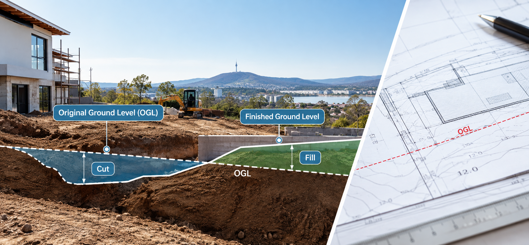
Open any set of civil drawings, and you will find a thin line running under the proposed works, labelled OGL. It gets ignored until something goes wrong. Then it becomes the only line anyone wants to discuss. A variation claim arrives. A certifier queries a wall height. A neighbour says the retaining wall is taller than approved. In all three cases, the answer depends on where the ground used to be.
This guide explains what OGL means, how it is established, who relies on it, and why sites around Canberra carry a complication that most Australian cities do not.
The Short Answer
OGL stands for Original Ground Level. It is the surveyed height of a site recorded before any earthworks begin, measured against Australian Height Datum.
An OGL survey captures an accurate geospatial snapshot of existing site conditions before works commence. It becomes the baseline that every later measurement is compared against.
Three things are calculated from it:
How much material was cut out and how much was filled in
How tall the finished building sits above the ground
How deep any retaining structure needs to be founded
Get the baseline wrong, and all three numbers inherit the error.
Clearing Up the Terminology First
Most disputes on site are not engineering disagreements. They are vocabulary disagreements. Four terms describe four different surfaces, and people swap them freely.
| Abbreviation | Full Term | What Surface It Describes | Primary User |
|---|---|---|---|
| NGL | Natural Ground Level | The surface before any human modification, cutting, benching or filling, however long ago | Planners, building certifiers |
| EGL | Existing Ground Level | The surface as it sits today, including old fill and past earthworks | NSW planning assessment |
| OGL | Original Ground Level | The surface surveyed at the start of this contract, usually after clearing and topsoil stripping | Civil engineers, earthworks contractors, quantity surveyors |
| FGL | Finished Ground Level | The designed surface once the works are complete | Designers, drainage and landscape teams |
The important distinction sits between the first and the third. Natural ground level refers to a pre modified ground level, before any alteration by cutting, benching, or filling. OGL is narrower. It records what was physically there on the day you took possession.
In civil and road work, OGL is often taken after site clearance and compaction, meaning after vegetation and topsoil have been removed.
That small variation has real money attached. Strip 250 millimetres of topsoil from a 2,000 square metre site and you have moved 500 cubic metres before the design cut even starts. Whether that volume sits inside or outside your contract depends entirely on which definition the specification used.
Clarity check: before you price anything, read the specification and confirm whether OGL is defined as pre strip or post strip. If the document does not say, ask in writing and keep the answer.
How is an OGL Survey Actually Produced?
The process is straightforward. The quality varies enormously.
Step one. A registered surveyor establishes a benchmark on or near the site, tied to Australian Height Datum. This is a fixed physical point of known height, such as a star picket set in concrete or a nail in a kerb.
Step two. The surveyor records spot heights across the site using a GNSS rover, a total station, a drone, or a combination. Each point carries an easting, a northing and a reduced level.
Step three. Those points are processed into a digital terrain model, which generates contours and allows volume calculations.
Step four. The model is issued as a drawing and a data file, signed and dated.
The step that decides everything is step two. Specifically, how far apart the points are.
If ground survey points are spaced at 20 metre intervals, it is not possible to accurately determine 0.5 metre contours on sloping terrain. Where a dispute later turns on height differences of 0.1 to 0.3 metres, the original survey points should have been 1.5 to 2.5 metres apart.
That is the whole insight in one sentence. Point spacing is not chosen by the terrain. It is chosen by the size of the argument you may one day need to settle.
A survey brief that holds up later should capture:
Spot levels on a grid tight enough to resolve the tolerance you care about
All boundary corners, plus kerb invert and road crown at the frontage
Existing pits, service covers, sewer lines and driveway crossovers
Tree trunks, drip lines and any vegetation to be retained
Existing retaining walls, batters, benches and stockpiles
Levels extending at least five metres past boundaries where neighbouring ground could be contested
A permanent benchmark located outside the works zone
That last item is the one people skip. A benchmark inside the excavation footprint disappears in week two, and re establishing the baseline afterwards becomes an opinion rather than a measurement.
Why OGL Controls the Earthworks Bill?
Earthworks are priced by volume. Volume is design level minus OGL, multiplied by area. There is no other input. So a baseline error does not cause a small problem. It scales directly into cubic metres.
The chart below shows the volume error created across a 1,000 square metre building platform when the recorded OGL is uniformly wrong.
OGL Error versus Volume Error
1,000 m² platform
Apply Canberra cart-away and disposal rates to the bottom two bars, and the exposure runs well into five figures on a single residential platform. On a townhouse site or a commercial pad, multiply accordingly.
Here is the point people miss. The excavator operator is rarely wrong. The machine removes what it is told to remove. What gets argued about later is the line the operator started from.
A Worked Example
A builder takes on a sloping block in Wright. Design pad level is set at RL 583.40. The OGL survey shows the high corner at RL 584.85 and the low corner at RL 582.90.
Average cut across the 220 square metre pad works out to near 0.28 metres, so roughly 62 cubic metres of cut and a matching fill requirement on the downhill side.
Now suppose the survey was taken after a previous contractor had scraped the block, and 200 millimetres of topsoil had already gone. The builder has just lost 44 cubic metres of measurable work from the claim. Nobody stole it. It was simply never recorded.
That is why the date on the survey matters as much as the numbers.
The Canberra Complication: Your Original Ground May Already Be Fill
This section is specific to how the ACT was built, and it rarely appears in general construction articles.
Large parts of Gungahlin, Molonglo Valley and West Belconnen were delivered through bulk earthworks. Developers cut and filled entire precincts before individual lots were released. So when a builder surveys OGL on a block in Whitlam, Taylor, Throsby or Denman Prospect, the surface being measured is frequently engineered fill rather than natural ground.
That fill is documented. Estate constructors routinely commission Level 1 inspection and testing for controlled fill under AS 3798, Guidelines on Earthworks for Commercial and Residential Developments. Typical specifications require fill placed in loose layers not exceeding 250 millimetres, compacted to at least 95 percent dry density ratio.
Two consequences follow, and both are practical.
First, the surface tells you nothing about what is beneath it. Controlled fill is commonly placed up to 300 millimetres below finished surface level, with the top 300 millimetres treated as topsoil rather than controlled fill. A rover reading the surface cannot detect that boundary. The geotechnical certificate can. Read it before you design footings.
Second, those certificates carry exclusions. Level 1 certification commonly excludes slope stability, reactive soils, pre-existing uncontrolled fill outside the treated area, service trench backfill, and topsoil placed after the controlled filling. Canberra clay is reactive. Assuming the estate certificate covers your footing design is a costly assumption.
So on an ACT greenfield lot you are working with two separate records. The OGL survey describes the shape of the ground. The estate geotechnical report describes its composition. You need both.
OGL, Building Height and Planning Approval
The earthworks baseline and the planning baseline are not always the same surface. This catches people out regularly.
In NSW, most councils use standard instrument local environmental plans. There, ground level (existing) is defined as the existing level of a site at any point, and maximum building height is measured as the vertical distance from that level to the highest point of the building.
The definition reads simply. Applying it is harder where past excavation or an existing slab has erased the original surface, and the Land and Environment Court has worked through the problem repeatedly in cases including Bettar, Strebora, Gejo and Nicola.
In the ACT, territory codes generally reference natural ground level rather than existing surface. Multi-unit housing provisions, for example, project building envelope planes at 30 degrees from a height of 3.5 metres above natural ground level at side and rear boundaries, up to maximum heights of 8.5 or 12 metres depending on the zone.
Put those together, and the risk becomes obvious. On a filled block, the surface you excavate from and the surface your envelope is measured from can sit at different heights. If you design to the wrong one, the design margin you assumed does not exist.
Clarity check: confirm early which reference surface applies to your approval pathway, and mark it explicitly on the drawings. Two labelled lines on a section remove an entire category of dispute.
The Perspective That Changes How You Treat OGL
Stop thinking of the OGL survey as a technical deliverable. Treat it as evidence.
Once the first bucket enters the ground, the original surface stops existing. Permanently. Almost every other project record can be reconstructed later. Invoices, diaries, photographs, delivery dockets, test results. The original ground cannot be reconstructed at all. If it was not measured properly, it is simply gone.
That makes the OGL survey the only genuinely unrepeatable document on the job. And the people who eventually need it- the quantity surveyor pricing a variation, the certifier checking height, the adjoining owner alleging loss of lateral support- all turn up months after it became unrecoverable.
Habits worth building into every project start:
Commission the survey from a registered surveyor, not from site staff with a laser level
Have it signed and dated, with the survey method and point spacing stated in the report
Issue it formally to the client and head contractor before works begin, and retain proof of issue
Photograph the site the same day with the benchmark visible in frame
Run a confirmation survey immediately after bulk earthworks, so the cut and fill volumes are independently supported
Store the file somewhere it survives staff turnover
None of this is expensive at the start. None of it is possible later.
Mistakes That Cost Money
Using the designer contour plan as OGL. Design contours are interpolated assumptions, not measured levels.
Surveying after the block has been scraped, which removes topsoil volume from your entitlement.
Placing the benchmark inside the works zone, where it will be destroyed.
Ignoring the estate geotechnical report on a filled lot.
Assuming one ground level satisfies both the earthworks contract and the planning code.
Skipping the post-earthworks survey, which leaves your volume claim unsupported.
Failing to record levels beyond the boundary before work starts near a neighbouring property.
Quick Answers
Is OGL the same as natural ground level?
No. Natural ground level describes the pre-modified surface. OGL describes the surface at the start of this contract, which may already include old or engineered fill.
Who should pay for the OGL survey?
Usually the party carrying the earthworks volume risk. Whoever pays, both parties should hold a copy before machines arrive.
How accurate does it need to be?
Accurate enough to settle the smallest dispute you can realistically foresee. For residential earthworks in the ACT, that generally means tight point spacing over the building platform and along boundaries.
Can OGL be reconstructed after excavation?
Only by inference, using surrounding levels, old survey plans or aerial data. Inference is arguable. Measurement is not.
Start the Job With a Defensible Baseline
OGL is the reference point behind every volume, height, and claim on your project. Sites that document it properly tend to finish without arguing about the first three weeks of work. Sites that do not tend to spend the back half of the program relitigating the front half.
Building, extending or developing across Canberra, the ACT or nearby NSW? Virk Construction Management coordinates survey, earthworks and approvals from the first site visit, so your ground levels are recorded and defensible before a machine turns up. Talk to Virk Construction Management about getting your project baseline set correctly.