
What is EGL in Construction? A Comprehensive Walkthrough

Published by Adeel Virk
Adeel is a founder & project manager at Virk Construction Management, delivering ethical, high-quality residential and commercial projects in NSW and Canberra.
If you have ever looked at a set of construction drawings and felt your eyes glaze over at all the abbreviations, you are not alone. EGL is one of those terms that pops up constantly on site plans, civil drawings, and development applications across Canberra, ACT, and New South Wales, yet it rarely gets a proper explanation. So let us fix that.
Understanding EGL is not just useful for engineers and surveyors. If you are a homeowner, developer, or project manager dealing with a build in Canberra or regional NSW, knowing what EGL means and how it connects to every level decision on your site will save you time, money, and a lot of headaches down the track.
Breaking Down the Acronym: What EGL Actually Means
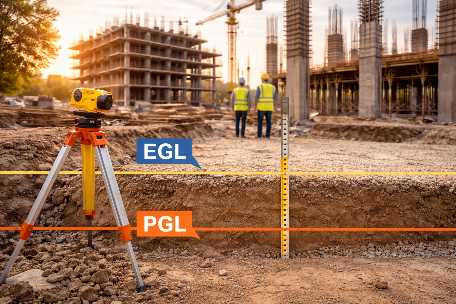
EGL stands for Existing Ground Level. It refers to the natural or previously modified surface level of the land before any new construction work begins on a given project. Think of it as a snapshot of the ground as it currently sits, taken at specific surveyed points across a site.
This is not a guess. EGL values are measured by a licensed surveyor who records elevations at multiple locations across the land parcel. These measurements are tied to a benchmark, usually expressed as a Reduced Level (RL) in metres above the Australian Height Datum (AHD), which is the standard reference system used across Australia.
So when you see something like "EGL RL 620.450" on a drawing, it means the existing ground at that surveyed point sits 620.450 metres above mean sea level.
Talk Through Your Project Before You Start
Get in touch with Virk Construction Management today. Early planning costs you nothing, but avoiding costly construction mistakes can save you significantly.
Get in TouchWhy EGL Matters on Every Construction Project
EGL is the starting point for almost every calculation that follows in the design and construction process. Without it, you cannot establish:
How much material needs to be removed (cut) or brought in (fill)
The finished floor level (FFL) of a building
Stormwater and drainage grades
Retaining wall heights and structural requirements
Building height calculations for planning approval
In Canberra and the ACT, especially, where planning regulations are strict and terrain can vary significantly across suburbs like Gungahlin, Belconnen, and the Inner South, getting EGL right from the outset is essential. The ACT Planning Authority uses ground-level data to assess whether a proposed development complies with height restrictions, setback controls, and earthworks limitations.
Errors in EGL can flow through to incorrect drainage designs, non-compliant building heights, and costly variations during construction. Getting this number right at the start is genuinely one of the best investments a project can make.
EGL, NGL, and FGL: Understanding the Key Difference
These three terms are related, but they're definitely not interchangeable. Plenty of people use them like they mean the same thing, and that's where projects start running into trouble. Here's a proper breakdown of each one.
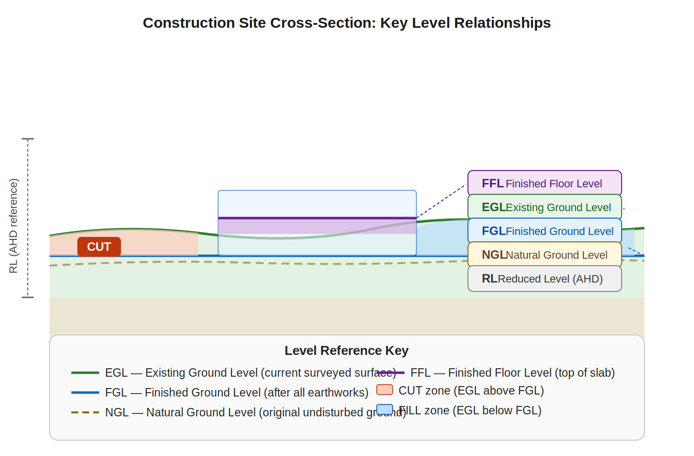
EGL: Existing Ground Level
This is the one you'll see most often on drawings. EGL is simply the ground as it sits right now, today, before your project touches anything. A licensed surveyor goes out, takes measurements at specific points across the site, and that data becomes your EGL. It's your baseline for everything that follows. Think of it as the "before" photo of your block. Every earthworks calculation, every drainage design, every retaining wall height calculation starts here.
NGL: Natural Ground Level
NGL is the original, untouched ground level before any human activity ever changed it. On a brand new greenfield site in a suburb like Gungahlin or Moncrieff, EGL and NGL are often identical because nothing's happened to the land yet. But on an older infill block in Braddon or Kingston? They can be worlds apart. Previous owners may have graded, filled, or excavated the site years ago. That history lives in the difference between EGL and NGL, and it matters a lot for planning assessments.
FGL: Finished Ground Level
FGL is what you're working towards. It's the proposed ground level once all the earthworks are done and dusted. Engineers and designers set the FGL to manage drainage, achieve the right floor levels, and meet planning controls around cut and fill depths. The gap between your EGL and your FGL tells you how much material needs to move. Big gap equals big earthworks bill. That's why comparing these two numbers early in design is so important. Getting FGL right saves serious money later.
FFL: Finished Floor Level
FFL sits one step above FGL, literally. It's the actual floor level inside the building once the slab or floor structure is complete. FFL is usually set a minimum height above FGL to manage drainage away from the structure and meet flood immunity requirements where they apply. In ACT and NSW, your certifier will check that FFL clears the minimum required freeboard above the finished ground. It sounds simple, but getting FFL wrong creates real waterproofing and compliance headaches down the track.
RL: Reduced Level
RL is the number that ties everything together. It's the actual elevation value, expressed in metres above the Australian Height Datum (AHD), which is essentially mean sea level. When your drawings say "EGL RL 620.450," that point on your block sits 620.450 metres above sea level. Every EGL, NGL, FGL, and FFL value on a set of drawings is expressed as an RL. Without RL, all the other levels are just floating numbers with no connection to the real world. It's the common language that surveyors, engineers, and certifiers all speak.
In a lot of Canberra builds, EGL and NGL end up being the same thing, particularly on greenfield sites in newer suburbs. But on infill sites, renovations, or blocks that have been previously graded or filled, EGL and NGL can be significantly different. That distinction matters a great deal in planning assessments and for retaining wall design.
| Aspect | EGL (Existing Ground Level) | NGL (Natural Ground Level) | FGL (Finished Ground Level) |
|---|---|---|---|
| Definition | Current ground level at the site before construction begins | Original, untouched ground level before any human activity | Final ground level after construction and landscaping work |
| Condition | May include previous modifications or disturbances | Completely natural and undisturbed terrain | Modified and adjusted as per design requirements |
| Usage in Projects | Used as a reference for site preparation and excavation | Used for regulatory approvals and environmental assessments | Used for final design levels, drainage, and compliance |
| Role in Design | Helps determine cut and fill requirements | Baseline for planning and comparison | Defines the final look and usability of the site |
| Impact on Drainage | May not support proper drainage | Reflects natural drainage patterns | Designed to ensure proper water flow and runoff |
| Stage of Use | Before construction begins | Pre-development reference stage | After construction completion |
How EGL is Established on a Construction Site
A registered surveyor carries out a site survey before design work begins. They use total stations, GPS equipment, or digital levels to record spot heights at a grid of points across the site. The denser the grid, the more accurate the EGL representation.
These spot heights are then translated into a contour plan, which shows the shape of the existing land as a series of lines connecting points of equal elevation. Architects, engineers, and certifiers all use this contour plan as their ground truth.
Here is what the survey process generally looks like in practice:
Site visit and benchmark establishment — The surveyor locates or places a physical benchmark on or near the site
Spot height collection — Elevations are recorded at regular intervals and at key features like boundaries, existing structures, and trees
Contour generation — The data is processed into a contour plan, typically at 0.2 metre or 0.5 metre intervals
Integration into design drawings — The EGL data is overlaid with the proposed design to calculate earthworks, drainage, and structural requirements.
For projects in the ACT and NSW, this survey data needs to come from a licensed surveyor. The Virk Construction Management team can help coordinate this process as part of a full construction management service.
Where You Will See EGL on Construction Drawings
EGL shows up in several places across a typical documentation set:
Site Plans: Site plans show EGL contours as thin lines running across the block, with the elevation value annotated. You will also see spot heights marked at corners and along boundaries.
Section Drawings: Cross sections through the site show EGL as a shaded or hatched line beneath the finished design. This is where you can really see the cut-and-fill relationship clearly.
Stormwater and Drainage Plans: EGL informs every fall calculation in the drainage design. Pipe inverts, pit entry levels, and overland flow paths are all calculated in relation to EGL.
Development Application Documentation: In ACT and NSW, development applications require a shadow diagram, elevation drawings, and often an earthworks statement. All of these references EGL to demonstrate compliance with planning controls.
EGL and Cut and Fill: Where Things Get Interesting
Cut and fill is one of the most significant cost drivers on any sloped site. EGL is the baseline for every cut and fill calculation.
Cut refers to material that is excavated and removed from the site because the ground sits above the proposed finished level. Fill refers to material that is imported and placed on the site because the ground sits below the proposed finished level.
The volume of cut and fill is calculated by comparing EGL (the existing surface) with FGL (the proposed finished surface) across the site. This comparison directly determines:
Earthworks costs
Retaining wall requirements and heights
Structural fill specifications
Import and export of material
| Scenario | EGL vs FGL Relationship | Result |
|---|---|---|
| Cutting into a hill | EGL is above FGL | Material excavated and removed |
| Filling a low area | EGL is below FGL | Material imported and compacted |
| Balanced earthworks | EGL and FGL are similar across the site | Minimal material movement |
| Complex terrain | Mixed cut and fill zones across the site | Requires careful volume balancing |
On sloped blocks in suburbs like Tuggeranong, Weston Creek, or the Murrumbidgee corridor, the difference between EGL and FGL can add tens of thousands of dollars to a project if not planned carefully from the start.
Common EGL Mistakes That Cause Costly Problems
Even experienced builders and designers can fall into these traps:
Using outdated survey data — Sites change. If a survey was done two years ago and earthworks have occurred since, the EGL data is unreliable.
Confusing EGL with NGL on infill sites — This leads to incorrect building height calculations and potential non-compliance with planning controls.
Not verifying EGL at connection points — Drainage connections, footpath interfaces, and neighbouring property levels all need to align with the EGL data used in design.
Assuming flat EGL on apparently level sites — Even sites that look flat can have 300 to 400mm of variation across the block, which is enough to affect drainage and floor levels significantly.
Working with a professional construction manager from the start means these issues get caught during design, not during construction, when changes cost far more. If you are planning a project in Canberra or the surrounding ACT region, the team at Virk Construction Management can help you navigate exactly this kind of technical groundwork before a single sod is turned.
EGL in the ACT and NSW Planning Context
Planning authorities in both the ACT and NSW reference existing ground level when assessing:
Maximum building height (often measured from EGL or NGL, not FFL)
Cut and fill depth limits (the ACT often restricts earthworks to 1 metre of cut or fill without additional approval)
Retaining wall height permissions
Basement and subfloor area calculations
Getting these calculations right at the development application stage prevents costly redesigns later. A thorough understanding of EGL is not optional for any serious construction project in this region.
Need Help Navigating the Technical Side of Your Project?
Understanding EGL is one piece of a much larger puzzle. From surveying and site analysis through to construction management and delivery, having the right team behind your project makes all the difference.
Virk Construction Management works with homeowners, developers, and commercial clients across Canberra, ACT, and NSW to deliver projects that are planned properly from the ground up, literally. Whether you are building a new home, managing an infill development, or tackling a large commercial project, the team brings the technical knowledge and on-the-ground experience to keep things on track.